Search the Community
Showing results for tags 'abris'.
Found 5 results
-
Can i somehow increase the font size of the UTM Grid references on the ABRIS? They would benefit from a dynamically scaled font size, but they stay in tiny 6px font size regardless of how far you zoom in. Did someone already create a mod for this perhaps or is able to whip one up real quick? Would be awesome.

-
 Introduction SharkPlanner has started a MOD for entry of waypoints into ABRIS and PVI-800 of DCS Ka-50 attack helicopter. The mod enables entry of: waypoints into ABRIS/PVI-800/NADIR fix points (used for INU/INS corrections) target points (used for autopilot ingress, SHKVAL slewing and DL operations) review of elevation profile along route Meanwhile SharkPlanner supports additional modules... FAQ How does it work? SharkPlanner runs as a LUA script hook and is able to utilize DCS's native UI in order to deliver minimalistic UI without requiring external application. Does it break integrity check? No, SharkPlanner is not deployed in your game installation folder. Do I need binary/exe? No, SharkPlanner runs within the DCS, and as such does not require external tools to run. Which DCS versions are supported? Minimal requirement is 2.8 either stable or openbeta. Which airframes are supported? BlackShark 3: Ka-50 version 2022 BlackShark 3: Ka-50 version 2011 BlackShark 2: Ka-50 Combined Arms (only information gathering) Gazelle: SA-342L Gazelle: SA-342M Gazelle: SA-342Minigun F-16C JF-17 Thunder How do I report bugs? Open the issues, read existing open issues to quickly figure out if your issue is already reported, and if you find none create new issue. Please try to be precise and provide the steps for reproduction and if needed: screenshots if available links to video if available mission file if available (needs to be renamed into zip, I recommend my_mission.miz.zip) dcs.log, located at %USERPROFILE%\Saved Games\DCS.openbeta\Logs or %USERPROFILE%\Saved Games\DCS\Logs If you do not have github account you can post error report here and I will create the issue on github page. Installation instructions Download the latest release. The needed package is named like this: SharkPlanner-VERSION.zip Unpack the content of the zip file into %USERPROFILE%\Saved Games\DCS.openbeta\Scripts or %USERPROFILE%\Saved Games\DCS\Scripts depending on version of the DCS you are using. Start or restart DCS Usage instructions Start DCS Hop into your Black Shark Switch to F10 mode Hit: CTRL+SHIFT+SPACE You should see a crosshair in the middle of screen. Above crosshair the following buttons are located: Hide, Add, Reset, Transfer as well as label showing current and maximal number of waypoints. Use your mouse to zoom and pan to your point of interest, and use Add button to select your waypoints. Once you add at least one waypoint, you can click on Transfer button and SharkPlanner will start entering waypoints/fixpoints/targetpoints into ABRIS and PVI-800. It is recommended to do this on ground for maximal accuracy. If you would like to create a new route, hit Reset and go to step 5. To hide SharkPlanner hit again: CTRL+SHIFT+SPACE Removal instructions To remove SharkPlanner: Delete file %USERPROFILE%\Saved Games\DCS.openbeta\Scripts\Hooks\SharkPlanner.lua or %USERPROFILE%\Saved Games\DCS\Scripts\Hooks\SharkPlanner.lua depending on version of the DCS you are using. Delete folder %USERPROFILE%\Saved Games\DCS.openbeta\Scripts\SharkPlanner or %USERPROFILE%\Saved Games\DCS\Scripts\SharkPlanner depending on version of the DCS you are using. Restart DCS if it was running Kudos TheWay is a very cool project which enables entry of waypoints for a rather large number of DCS airframes. My initial motivation was to provide the ABRIS support as code contribution to TheWay, but ABRIS proved to be very challanging to implement within existing framework since coordinates entry can be done only non-numerically through dials. This limitation has resulted in large changes that could not be easily harmonized and tested with existing code base. Please note that TheWay remains to be the most comprehensive software for waypoint entry in DCS and is highly recommended to use for all other supported aircrafts. You can use both SharkPlanner and TheWay as long as you remember not to invoke transfer of waypoints at the same time! DCS Scratchpad provided the idea how to inject the UI and trigger it with a keyboard shortcut.
- 57 replies
-
- 14
-

-

-
Abris flickering since the last update. BS3 have same issue than BS2 (an other topic have been create for BS2) : https://forum.dcs.world/uploads/monthly_2023_10/Ka-50ABRISFlickering.mp4.2c8037a22b69a602c2be7043caaeba24.mp4
-

solved Abris of Ka-50 not in English but in Cyrillic
calys posted a topic in DCS: Ka-50 Black Shark 3
Hi friends, a friend of mine has a problem with his Ka-50III. He has a new computer and reinstalled everything, including DCS. To use his Ka-50 he has set English as the language for his instrumentation, but what is particularly strange his abris keeps displaying information in Cyrillic. We searched this forum for the possible solution to the problem and found it in the modification of the file, "\Eagle Dynamics\DCS World OpenBeta\Scripts\Aircrafts\_Common\Cockpit\localizer.lua." The modification suggested by a forum friend said to replace the contents of the file this way: Original: if LockOn_Options.avionics_language == "native" then country = "RU" end Modified: if LockOn_Options.avionics_language == "Russian" then country = "EN" end It actually works but from then on DCS recognizes the integrity check compromised. What do you think could be the solution to this problem? Thank you -
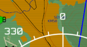
 Tactical Information (DL and Nav Target Points) are always showing on ABRIS for a specific mission. I understand that ABRIS is able to store information on a persistent (per mission) database, and this might be what has happened. What I am unable to do is to clear old Datalink and Nav Target points from the database. I have tried various things on the CTRL/DTB page but with no luck... I can't find any documentation for clearing data. I know it is called the "Tactical information" from the OPTIONS/CHART page, where I am able to disable the layer entirely - but this does not solve it for me because I need this info for the mission. I am also unable to select the target points with Datalink or PVI to manually clear them one by one. Search for a solution for quite a bit on the net, but no luck there either. So I turn to you.